After 300 years, ruins are emerging of this rebellious city that Spain tried to erase
A lost Maya city has stepped back into view after three centuries of silence. The site, called Sak-Bahlán, or Land of the White Jaguar, sheltered Indigenous rebels during the 1500s and 1600s.
Researchers combined old letters with modern mapping to find it inside the Lacandón Jungle of southern Mexico.

The result gives shape to a community that outlasted repeated military campaigns and then vanished from official maps.
Finding the lost city of Sak-Bahlán
The work was led by Josuhé Lozada Toledo, an archaeologist at the National Institute of Anthropology and History (INAH).
His team focused on a remote stretch of the Montes Azules Biosphere Reserve, a large humid tropical forest in Mexico and Central America .
Spanish authorities subdued the settlement in 1695, and by 1721 it was abandoned, bringing to a close about 110 years of occupation that had begun after the fall of the earlier capital in 1586.
Archaeologists now point to a location near the border with Guatemala, close to the Jataté and Ixcán rivers, where historical descriptions and fieldwork appear to converge.
The geography of this area matches colonial accounts that described river routes and travel times, strengthening the case that the site corresponds to the long-lost city.
What the colonial records said
Seventeenth century accounts guided the modern search. A 1695 letter described the city as being located on a plain beside a bend of the Lacantún River, offering one of the main clues to its position.
The same records outlined a four day walk from the site to the river and then a two day canoe trip to the junction with the Pasión River. Those times became the backbone for route modeling.
How modern tools narrowed the search
The team used GIS or geographic information systems to build a predictive model that weighed terrain, current and historic waterways, and realistic travel speeds for soldiers and porters.
A project paper by Lozada details how those variables define a probable search ellipse.
Researchers then overlaid that model with satellite basemaps and topographic layers to target walking surveys.
The approach helped concentrate scarce time and resources on the few places that fit both the math and the colonial text.
Preliminary mapping and trenching aim to match architecture and ceramics to the dates in the documents.
Early work has focused on verifying whether the surface remains aligned with a settlement that was still active in the late 1600s.
What the team found on site
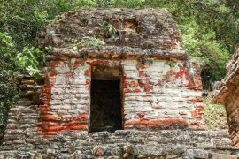
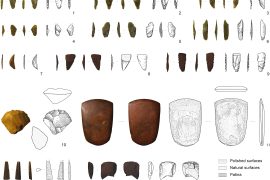
Field seasons logged stone foundations, ceramics, and Spanish era remains, including a small church ruin that fits the Sak-Bahlán’s late colonial chapter.
Excavations and dating tests are now underway near the Jataté and Ixcán rivers to confirm the site’s identity.
“It was the most arduous field trip I’ve ever had in my life, but in the end, we found the archaeological evidence, right at the spot I had marked,” said Lozada.
The quote underscores how a desk built model held up under real jungle conditions. It also signals that the core hypothesis is passing early checks.
Why Sak-Bahlán matters today
Sak-Bahlán served as a refuge for the Lacandon Ch’ol, a Maya group that resisted Spanish attempts to move them into colonial towns.
For more than a century, they maintained their independence deep within the jungle, far from the control of Spanish authorities.
The term Lacandon originally referred to several unconquered lowland groups who shared cultural ties but lived in separate communities.
Over time, the blending of these groups shaped what is recognized today as Lacandon culture, preserving elements of their traditions while also reflecting centuries of adaptation and change.
Archival narratives describe how, after the 1695 occupation, colonial authorities moved many Lacandon Ch’ol to highland communities in Guatemala.
Over the next decades they merged into neighboring Maya populations, which helps explain why the original city faded from memory.
It also widens the lens on how resistance worked in daily life. Food storage, water access, craft production, and ritual spaces all become data points for how a community sustained itself while avoiding the road grid of empire.
What the science can add next
Archaeology can now test the predictive model against buried streets, house compounds, and defensive lines. If the model predicts a route and a causeway shows up in that corridor, confidence in the method rises.
Specialists will also track trade networks through obsidian sources and metal artifacts. Those finds can reveal whether rebels relied on nearby allies or tapped wider exchanges.
Chronology will be refined with radiocarbon and ceramic seriation to bracket the start and end of the settlement. Matching those dates to specific entries in colonial logs can lock the site’s identity beyond doubt.
This discovery connects historical memory to measurable ground evidence. It respects testimonies that spoke of a hidden city and shows how a careful read of those texts, paired with modern tools, can surface places that were meant to be forgotten.
The work also turns attention to ordinary people who held their ground for a century. Their city, their foodways, and their roads now have coordinates, not just stories.
—–
Like what you read? Subscribe to our newsletter for engaging articles, exclusive content, and the latest updates.
Check us out on EarthSnap, a free app brought to you by Eric Ralls and Earth.com.
—–


News coming your way