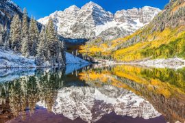
Measuring snow in the right places can greatly improve water forecasts
For a century, Western water forecasts have leaned on a simple idea: more mountain snow means more water in rivers in the spring. But where you measure that snow matters as much as how much you measure.
A new analysis of more than two decades of data across 390 snow-fed river basins in 11 Western states shows that placing new instruments at strategically chosen “hotspots” consistently delivers better water supply forecasts than trying to blanket an entire basin with broad surveys.

In those basins, adding hotspot sites improved forecast skill by about 11–14 percent on average. By comparison, doing comprehensive basin-wide snow mapping nudged forecasts up by only about 4 percent on average.
The takeaway is surprisingly straightforward: measuring snow in the right places can help far more than measuring snow everywhere.
Where snow matters most
Hotspots are small areas within a watershed where snow conditions punch above their weight in predicting how much water will actually reach streams months later.
Think of ridgelines, aspects, or elevations where snow tends to persist or melt in patterns that strongly control downstream flow.
Because most existing ground stations sample a tiny fraction of a basin, there’s room to improve forecasts by adding just a few stations – if they’re placed where the snow signal matters most for runoff.
Putting snow sites to the test
Researchers sifted through more than 20 years of snow estimates and streamflow records, comparing two expansion strategies for monitoring: adding targeted hotspot gauges, or rely on basin-wide mapping (from aircraft or satellites) to capture total snow volume.
They tested both approaches against the current network of ground stations that operational forecasters use today.
The team treated streamflow forecasting the way a water manager would, asking how much each strategy improved the year-to-year predictive power for seasonal water supply.
Because different basins respond differently, they repeated the analysis for hundreds of watersheds, from the Cascades and Sierra Nevada to the Rockies and the Great Basin.
Across that breadth of climates and terrains, the pattern held – focused hotspot measurements typically outperformed broad coverage.
Airborne snow measuring has tradeoffs
Basin-wide surveys are undeniably powerful. Airborne campaigns can directly estimate a basin’s total snow volume, and satellites help paint the big picture over vast, remote areas. The catch is cost and cadence.
Airborne surveys are expensive and can’t fly everywhere all the time. Satellite products are improving quickly but still struggle with forests, clouds, and complex terrain, and they need ground truth to keep forecasts anchored in reality.
By contrast, a handful of well-placed ground sensors can run all season, in all weather, at a fraction of the price.
The new study shows those stations can deliver similar – and often better – forecast gains precisely because they target the parts of a basin that control when and how snowmelt becomes streamflow.
Snowmelt and a warming West
On average, about half of the water in Western U.S. streams comes from snowmelt. Cities plan reservoir releases and farmers schedule irrigation based on spring forecasts issued months ahead of peak demand.
But warming winters are shrinking mountain snowpacks and making melt timing jumpier, which raises the stakes for every improvement in prediction.
With budgets tightening, the findings offer a practical roadmap: expand monitoring, yes – but do it surgically. In many basins, adding a few instruments at hotspot locations will deliver more value than trying to map the whole watershed every time snow falls.
What water managers can do now
One of the most useful outcomes of the study is a framework for identifying where new measurements will help the most.
Rather than guessing, agencies can now screen a basin to find untapped areas whose snow signals are especially predictive of downstream flow and focus new stations there.
The same framework highlights where basin-wide mapping will add value – for example, in large, highly variable basins where total snow volume swings widely from year to year.
In short, there isn’t a single “best” strategy for every watershed. But there is a smarter sequence: start by asking where a new measurement would most improve the forecast, then pick the tool – a ground station, an aircraft flight, or satellite data – that fits the need and the budget.
Adapting as snowlines shift
Hotspot monitoring isn’t a magic wand. Some basins still benefit from periodic aerial surveys to capture the full snow picture, especially after major storms or in places with complex rain-snow transitions.
Satellites remain essential for regional situational awareness. As climate change pushes snowlines higher, the locations of the most informative hotspots may shift, requiring the network to adapt.
The encouraging news is that the ingredients for better forecasts already exist: decades of streamflow records, a century of snow-station data, rapidly improving remote sensing, and now a tested way to combine them so that each new measurement counts.
The study also shows that many forecasters are closer than they might think to an optimally balanced network – one that blends a few carefully placed new stations with occasional basin-wide snapshots to keep tabs on the big swings.
Measuring what matters most
Snowmelt will remain the West’s water engine, even as climate change makes it less predictable. This work suggests a practical, budget-savvy way to squeeze more certainty out of the same mountains: measure the snow where it matters most.
When every acre-foot counts, a handful of well-chosen hotspots can do more for tomorrow’s water plan than trying to see everything everywhere all at once.
The study is published in the journal Nature Communications: Earth and Environment.
—–
Like what you read? Subscribe to our newsletter for engaging articles, exclusive content, and the latest updates.
Check us out on EarthSnap, a free app brought to you by Eric Ralls and Earth.com.
—–


News coming your way